Today was the kind of day that makes you want to quit your vacation and go back to work.
We set out early from St. George toward the North Rim of the Grand Canyon. Unlike the much more popular southern approach, there's only one road that goes there — you can't just drive around the circumference. Our route ran through Hildale and Colorado City, adjacent towns straddling the state line and formerly known as Short Creek. After the LDS church had to officially renounce polygamy so that Utah could become a state, Brigham Young sent his most loyal followers to this region to quietly carry on the plural life. Their descendants have kept on keeping on, though their church is completely separate from the official LDS church in Salt Lake City.
I'm fascinated by the topics of polygamy (the only thing fundamentalist Mormons have in common with Hugh Hefner) and religious minorities, so I was pretty interested to drive through town and see what it was like. I had a vague idea that we'd buy gas, or have breakfast, or stop in at a convenience store or something, and get to meet some FLDS.
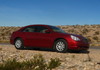
When we arrived, however, I noticed that every single car — both on the road and in the driveways — was either a giant pickup or an SUV. We were in a maroon Chrysler Sebring.
After one block, the paved street became dirt and I started feeling really uncomfortable. I didn't see anywhere to stop and eat and so we started back toward the highway.
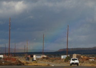
That's where Mike noticed a gorgeous rainbow on the horizon. He jumped out of the car to snap a picture, but again I felt conspicuous in my jeans and V-neck, so I stayed in the car. While Mike was framing his shot, a black pickup pulled into the space next to ours, and a large man and his two large sons got out. I looked away. Finally Mike came back toward the car and the three got in their truck and drove away.
At this point, I was terrified. Just two weeks ago the head of the FLDS church, Warren Jeffs, was sentenced to 10 years in prison, so I'm sure the community's already on edge. My heart was pounding as we hightailed it out of there.
I was disappointed in myself for being so timid, and also for not looking at a map of the town before heading over: It turns out that Highway 389 isn't the main road — Central Street is, a few blocks east.
I was also really hungry by this point — we'd planned to breakfast among the FLDS, and that hadn't worked out. The only place we could find was a roadside cafe in Fredonia, where a surly waitress served us BLT's on moldy bread.
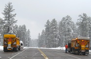
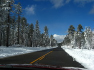
We gained elevation as we drove toward Jacob Lake — the junction with Highway 67, the one road to the North Rim. As we approached we started noticing snow on the ground. We knew that Highway 67 closes for the winter after the first snow of the season, but our Plan B was in the same direction, so we crossed our fingers and counted down the miles. The snow grew deeper as we climbed higher. It was beginning to hail.
When we got to Jacob Lake the gas station was unmanned and the inn was closed, but the "ROAD CLOSED" fence was not yet swung into place. We saw a pair of giant snowplows flanking the highway entrance, bearing the insignia of the Arizona Department of Transportation. We pulled alongside one and inquired about the conditions.
He said that they had just finished plowing the road, but that their jurisdiction ended where the National Park's land began: 11 miles shy of the admission gate (or any other inhabited building). The Park Service had called the DOT that morning and asked them to plow the state's section of the road, but they hadn't yet cleared their own side.
"Do you think we can make it?" we asked.
He shrugged. It had been 40 minutes since they turned around at the border, and it would be another 40 minutes before we reached it ourselves. Maybe the rest of the road would be cleared by then.
"We'll be coming up behind you, in any case." Due to the still-falling hail and the wind's undoing of their work, they were going to do another round trip.
Mike and I looked at each other. We had kind of hoped the plow drivers would call us crazy and send us on our way, but now we had to make a choice. It was only 12:30, many hours before night would fall. We'd come this far, and probably wouldn't be by this way again. So although I would have felt better in an all-wheel-drive or with a set of snow chains in the trunk, we decided to go for it.
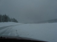
The plowman wasn't kidding about the wind, which was blowing to our left and thus throwing snow all over our lane. The worst conditions were high on a mountain pass where the sky turned dark gray and the hail became sleet. It was hard to see the road, but there wasn't room to turn around, so we just kept going. The last cars we had seen were way back at the beginning of the road: pickup trucks, each with a freshly-cut Christmas tree in the bed. (Is it legal to cut down trees in Kaibab National Forest?)
At one point we saw a yellow roadsign indicating that we could hear park and road information on 1610 AM. We tuned in and heard... silence.
As promised, it took 40 long minutes to reach the park entrance. It wasn't plowed. There was no way we we going any farther without a snowmobile.
At least the DOT plows had left a sort of cul-de-sac there when they had turned around. We, too, turned around and drove 40 long minutes back to Jacob Lake, defeated.
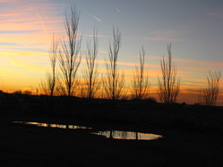
We continued east on 89A, and within 20 minutes reached lower elevation, clear skies, and the desert heat. It was unbelievable that two such different worlds could exist right next to each other. We later found out that the average temperature differential is 30 degrees!
Taken at 2:16 PM
|
Taken at 2:47 PM
|
We crossed the Colorado River at Navajo Bridge and continued on to Page, AZ.
Page isn't far from Coyote Buttes, part of the Vermillion Cliffs Wilderness and subject of an effusive LA Times article only days prior. Famous for a rare and incredible structure known as the Wave Formation, photographers flock from all over to see it (especially now, thank you very much Los Angeles Times).

Worse, it's not the kind of terrain that can take hordes of tourists tromping through endlessly, so the Department of the Interior limits the number of visitors to just twenty a day. Yeah, twenty. Half of the permits are made available via the Internet, but you have to apply four months in advance. The other half are offered in a morning lottery, held at 9:00 AM in a building an hour and twenty minutes away. We really wanted to see it, so we were going to wake up early and give it a shot, although we expected the odds to be approximately on par with getting into Harvard.
Once again, though, we failed to do our homework — the lottery issues permits not for the same day, but for the following one. Even if we'd won, we'd have to spent another night in Page to use it. Worse, in the winter they only conduct the lottery on weekdays. The passes for Saturday, Sunday, and Monday are issued Friday morning. We learned this when we checked into our hotel on a Saturday. Oh well. At least we found out before we drove 147 miles round-trip without breakfast.
(As a service to our readers, here is a link to some fantastic pictures of The Wave taken by a photographer named Linus Zumberge.)
So we didn't get to meet polygamists, we didn't get to see the Grand Canyon, we didn't get to see the Wave Formation, all in one day... a day, I might add, which included both freezing our butts off and baking in the sun. Now I know what a TV dinner feels like.
We got into bed that night, looking to put it all behind us and start anew.
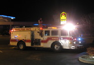
Then the fire alarm went off.
Down in the lobby, the desk clerk was explaining to the growing crowd that the heater had just kicked on for the first time all year and must have belched out some smoke. The only one on staff at that hour, he had already investigated the problem, ensured that the heater was okay and not actually on fire, and now wanted to focus his attention on turning off the deafening siren.
However, a small group of insistent guests were quizzing him on his level of diligence: Was he sure the alarm zone corresponded to the heater room? Was he going to reset the alarm or disable it? Were fire trucks rushing to the scene?
As for the last one, he explained that in big buildings like offices and hotels, management has the authority to call the fire department and cancel a false alarm.
This didn't sit well with one woman in the crowd, who called 911 and insisted they send someone. "There's smoke everywhere!" she lied. I of course dashed outside with the camera, and within minutes there were flashing lights and sirens wailing toward us: two fire trucks, two ambulances, and a gaggle of soon-to-be-annoyed firefighters.
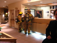
As the first firefighter burst into the building, another hotel guest leaned over and sniffed, "About time. 20 minutes later you guys finally decide to show up, huh?" (It was only 5 minutes since that lady had called on her mobile phone, and 10 tops since the alarm went off.) The firefighter walked past him and over to the desk. The guy who'd made the remarks turned to me, shook his head, and said "That's Page for you!"
The head fireman came back out and told his men to leave their "irons" (axes?) on the truck. "Manager says he didn't call, must've been a guest." "It was a guest," I told him. "Was it you?" he asked. I shook my head. "No, but I was there when she called. I don't see her anymore; she must have decided it was safe after all."
The fire trucks left, Mike put away the camera and came back inside, and we went to bed.
When we woke up, we had a new problem to deal with. For days, a dashboard indicator would flicker on now and then reading "BRAKE" — often when we were high in the mountains on scary winding roads and really needed our brakes to be in top shape. However, after a minute it would go off and usually stay off for the rest of the day. It was just another factor that had made Highway 67 so nerve-wracking.
We knew the parking brake was off, so we concluded that the brake pads must be overheating, and started driving in lower gears as much as possible. We had planned to get it fixed in Flagstaff.
This morning, though, the "BRAKE" warning was on when we started the car. Page is completely flat and there's no traffic, so we decided it could at least wait until after breakfast. After driving one block, the brake pedal started to shudder, the light started blinking, and the pitch of the warning tone got increasingly urgent. Flagstaff was 2.5 hours away but still the nearest city, and I wasn't going to trust this car to get us there.
We called Hertz during breakfast and got transferred to the Emergency Roadside Assistance operator. The first words out of her mouth were, "Are you calling from a safe location?" We were (unless you count cholesterol), and agreed with the operator that it was time for a new car. Miraculously, Hertz had an office in Page, thanks to a small municipal airport. We thanked our lucky stars and reserved a replacement.
When we returned to our car after breakfast, the problem had naturally disappeared completely, but we traded it in anyway.
Our best guess was that the brake fluid was low. As Hilary realized, the problem only happened when the car was cold — either in the mountains or on a freezing Arizona morning. Cold temperatures make liquid contract, so if the fluid level was borderline in warm air, it could be dangerous in the freezing mountains. The car was from LA, where it never gets this cold, so it's understandable (though not excusable) that their maintenance crew never noticed.
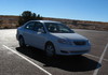
Our new car was a 2008 Toyota Corolla. Here's how it compared:
|
| |
|---|---|---|
| Make | Chrysler | Toyota |
| Model | Sebring | Corolla |
| Odometer (initial) | 19547 | 6723 |
| Odometer (final) | 20903 | ????? |
| Fuel effeciency | 21 / 29 | 26 / 35 |
| Fuel capacity | 16.9 gal | 13.2 gal |
| Feel | Boatlike | Plasticky |
| Keyless entry | Yes | Yes |
| Keyless trunk | Yes | No |
| Aux in (for iPod) | Yes | No |
This would seem like a fairly even trade, except for two final factors.
First, the Sebring had a number of annoying "features" that nobody ever asked for:
Second, the Corolla has GPS! The device has its own set of annoyances, and you can't trust its directions, but it's really helpful to always know exactly where we are.
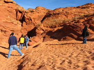
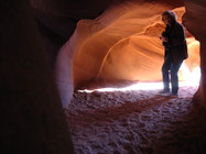
The area around Page is known for its slot canyons, particularly one called Antelope Canyon. It's located on Navajo land, and they require all tourists to be accompanied by a guide.
This is smart on the Navajo Nation's part, since the guides prevent vandalism (the canyon was pristine). And it was convenient for us, since they drove us from Page out to the canyon over unpaved sandy clay.
However, it also meant that we paid $25 each to be led through the canyon with about a dozen loud and annoying tourists, including both the woman who'd called the fire department the night before, and the man who'd given them grief about their response time. They all seemed to be the kind of people who like to talk a lot, whether or not they have something to say. Mike and I would have preferred a quieter walk at our own pace.
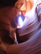
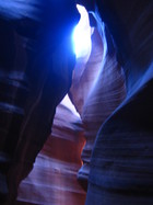
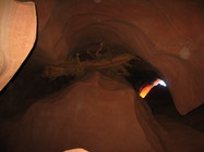
It was beautiful, though. The canyon is carved out of sandstone by flash floods: Though this is a dry climate, when it rains, it pours. When the rush of water is forced into a narrow path, it cuts into the canyon floor while also smoothing and rounding the walls. Slot canyons are very dangerous during rainstorms: Even though the walls are 135 feet high at their tallest, the canyon is so narrow that it fills with water almost to the top.
Winter isn't the prime time of year to view Antelope Canyon — most people prefer to come during summer, when the Earth is aligned in such a way that sunbeams shine through shafts in the rock and illuminate the twisting passages. The winter sun never gets high enough for that, but the layers, shapes, and colors are still unusual and gorgeous.
|
|
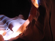
A passageway known as "The Candle"
|
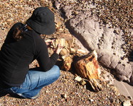
This log was wedged 30 feet above our heads — and the only way it could have gotten there is atop a flash-flood river.
|
"Oh, hi, do you mind if I stand in the middle of your picture?"
|
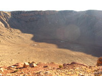
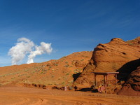
On our way across Arizona, we started seeing signs for a meteor crater. Hilary had actually heard of this crater before; apparently it was a particularly famous one. We had to drive six miles down bumpy Meteor Crater Road to reach the site, and there were a series of signs informing us of the amazing experience we were allegedly in store for.
I started feeling a vague sense of Deja Vu; this was reminding me of something. Eventually I realized that the last time I had seen such an aggressive "Come see our amazing roadside attraction! You'll be amazed!" campaign was years ago in South Dakota, where I made the mistake of taking a detour to the epitome of all tourist traps, the Corn Palace. If someone ever creates the Tourist Trap Hall of Fame, the Corn Palace will be in the inaugural class of inductees, along with Four Corners and the Hall of Fame itself.
Despite this recollection, we remained on Meteor Crater Road until its eponymous terminus. After paying the $15 per person admission fee (hey, we drove this far... it would be stupid to turn back now), we headed inside, past the gift shop and museum, and out to the crater. We knew the odds were slim that they'd let us walk down into it, but we had expected to at least be able to hike the 2.2-mile circumference. Lamely, the path was fenced in after about 100 feet. Since the winter sun was casting a shadow across half the bowl, this kinda ruined our photographs.
Disappointed, we went back inside to see the museum. Hilary had by this point filled me in on what made this particular meteor crater so special: Before the 20th century, scientists believed that meteors never impacted Earth's surface; the presumption was that they would always get vaporized in the upper atmosphere. All craters on this planet were believed to have been caused by volcanoes or other terrestrial phenomena.
However, a geologist named Daniel Barringer was convinced he could prove this crater was indeed a meteor impact site — and in 1906, he did. Besides the astronomical implications (so to speak), this breakthrough was key in solving the once-great mystery of what had happened to the dinosaurs.
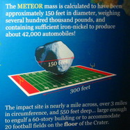
None of this was mentioned in the museum, whose exhibits instead focused on such weighty topics as the number of football fields one could fit inside the crater.
The icing on the cake was the imitation park ranger uniform all employees were wearing. And here I thought it was illegal to impersonate government officials.
This place is nothing like the great national and state parks of the American Southwest. Avoid it.
Instead of wasting your time at the crater, head over to nearby Petrified Forest National Park. We entered at the north entrance, and although we discovered that this part of the park doesn't actually have much petrified wood, what it does have is colorful rolling hills and plenty of Anasazi ruins.
The first trail we came to was the Painted Desert Rim Trail, which winds along near the road for a half mile or so. Technically, we'd been in the "Painted Desert" region since we left Page the day before, but this ridge overlooking the hills really showcased why they call it that. It has interpretive signs describing the various desert plants.
It also had the most animal life we saw in the whole park: one rabbit and one lizard.
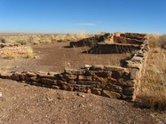
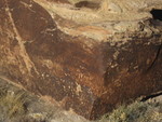
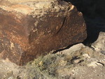
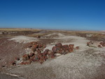
At Puerco Pueblo we saw the 800-year-old foundations of an Anasazi village. Although the park service has rebuilt portions — using historically accurate mortar — the stones and their placement are as they were around the year 1200. Additionally, some of the nearby rocks are decorated with ancient drawings known as petroglyphs.
There were even more petroglyphs a few miles down the road, on a boulder so covered in drawings and astrological markings that it's called Newspaper Rock. A friendly ranger named Tara helped us see the most interesting ones through the stationary binoculars.
If you click the pictures below, you can get a closer look at some of these mysterious paintings.
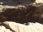
Petroglyph
|
Petroglyph
|
Petroglyph
|
Not a petroglyph
|
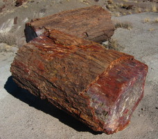
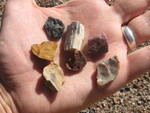
There were signs posted all over reminding visitors not to remove any petrified wood from the park. You can buy all you want, since it comes not from the protected parkland but rather from the surrounding, privately owned areas.
Back in the late 1800's and early 1900's, there were no such rules, and millions of tons were taken for both industrial and ornamental purposes. When the railroad — and later, Route 66 — were built through the area, tourists could just stop and gather as much as they could carry. Luckily the area was protected before it was stripped bare, but it's still sad to hear how much rock disappears every year.
There's still a lot left, though, and when you reach the southern half of the park, you start seeing it everywhere. Mike's going to tell you about that.
When I was younger, I used to think the Petrified Forest was a giant, well, forest. I imagined towering stone trees with jade leaves and, perhaps, crystal songbirds that lay Fabergé eggs. This turned out not to be the case.
A more accurate name for this park would be, "The Petrified Driftwood Collection." Don't get me wrong — the park is a must-see for anyone passing through this part of the country, and it's absolutely loaded with petrified wood — but let's set the record straight right now with a quick history lesson.
About 225 million years ago (right around the time of the first dinosaurs), the North American continent was located down by the equator. Arizona was covered with thick-trunked trees and experienced massive amounts of rain.
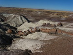
The inevitable floods would knock these trees down and carry them hundreds of miles, until they got stuck in one of the largest logjams the world has ever known. The trees didn't rot because they were covered in mud — mud that was saturated with silica from nearby volcanoes. The silica seeped into the wood and fossilized its tissues, and when continental drift and climate change dried the place out, the Petrified Forest was formed: a flat desert riddled with bits and chunks of petrified wood.
Forest or logjam, we like petrified wood in any form, so when we found out that the seven hiking trails add up to just six miles, we decided to see them all.
When you visit a national park, walk at least some of the hiking trails.
You might be thinking, "Oh, the last time I went to a national park, we drove the main road and pulled over for the scenic vistas, and that was good enough for me," but that's like admiring the Las Vegas skyline from the interstate and not actually visiting the Strip.
If you don't walk the trails, you're missing about three quarters of the park — the best three quarters.
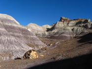
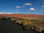
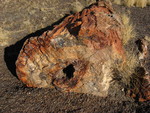
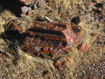
Just about any of the trails at Petrified Forest will show you enough petrified wood to last you the rest of your life, but two trails were particularly nice. The Blue Mesa trail is the most unique area of the park. It's named after the striped blue hills surrounding the path, which contrast beautifully with the brown chunks of petrified wood scattered across the landscape. The brochure warns that the uphill climb back to the parking lot can be "moderately strenuous", but it's no more difficult than going up the ramps to the cheap seats at a ballgame.
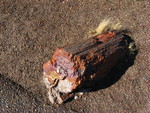
The Crystal Forest trail was short and to the point: the best specimens in the park, just lying there in the dirt next to the trail.
|
|
|
|
|
|
You can see more pictures of the Petrified Forest, Antelope Canyon, and snowy Highway 67 in our Arizona set on Flickr.
Previous spot: Nevada and Utah -*- First time here? -*- Next spot: New Mexico
If you'd like to be notified when we post a new spot, you
can join our announcement list. We won't use your address for
anything else or share it with anyone, and
the link to
unsubscribe will be at the end of every message.
