New Mexico was full of wows.
It started with El Malpais National Monument. For those of you who don't speak Spanish, that means "The Badlands" — so named because of the rocky black and gray terrain, formed by dozens of now-dormant volcanoes. The most unusual formations are the lava tubes, underground tunnels that were once flowing rivers of molten rock.

Exploring the tubes requires technical caving equipment, but we were able to get a look at one that had partially collapsed and formed a sinkhole.
Another, more interesting lava tube is on private land just outside the park. Known as The Ice Cave, it houses a small pond that stays frozen all year round — the volcanic rock around it, being porous, is an excellent insulator.
Scientists drilled into the ice and found samples near the bottom to be thousands of years old. The Native Americans knew of the cave, and called it Winter Lake. Later settlers mined ice from the cave to chill their iceboxes in the days before refrigeration.
The owners have built a wooden staircase leading from the trail down to the cave, and as we descended we could feel the refreshingly cool air wafting towards us. The stairs end at a platform 10 feet or so above the ice. It was a warm day, so we enjoyed the cool air for a few minutes before heading back up.

Entrance to the ice cave also includes access to Bandera Volcano. We climbed all the way to the rim and were able to look down inside. It was dormant, so instead of a lake of boiling lava it just had a grove of pine trees.
After the Meteor Crater, we were pretty wary of another privately-owned tourist attraction, but this one turned out to be worth the price of admission.
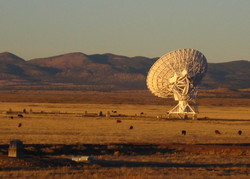
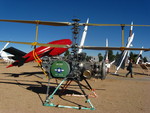
Our next stop was a very large array of satellite dishes, known rather uncreatively as the Very Large Array. The name is no exaggeration: each is as wide as a baseball diamond and weighs about as much as 100 Hummer H3's. There are 27 of them, arranged in a giant Y. Each of the Y's arms is 13 miles long. To put it another way, the array's diameter is the length of a marathon.

Such a massive installation could only be located in the middle of nowhere, and since El Malpais was merely on the outskirts of nowhere, we had a long drive ahead of us. A park ranger had described the trip as "desolate," but we found it quite interesting, with lava fields on one side and sandstone cliffs along the other. The catch, though, is that scenic routes always take twice as long and we needed to reach the VLA by closing time, i.e., sundown.
As we raced the sun across New Mexico, we counted off the towns on our map, one little dot at a time. One of the last was named Pie Town. It developed around a 1920's roadside pie stand and has catered to generations of hungry high-desert travelers like ourselves. The entire town, however, seemed to be closed for the winter, which was a shame because after all the anticipation we were really hankering for some apple pie, cherry pie, banana cream, key lime, huckleberry... you name it.
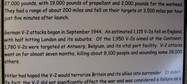
As soon as we left No Pie Town, we found ourselves in cattle country. We were watching the herds graze when we first spotted this on the horizon:

|
The sun was low in the sky but we knew we had made it in time. We went through a few railroad crossings (which was weird because our map showed no signs of any train routes through the area) and reached the parking lot. It was empty. The tour was outdoors and self-guided, so we just started walking around.
This is probably a good time to mention why there are 27 satellite dishes arranged in a giant Y high on a mesa in the middle of nowhere. But first, a one-paragraph science lesson:
Light and radio signals are the same thing. Red light, blue light, infrared, 94.5 "The Buzz", X-rays, gamma rays: it's all one continuous spectrum. This means you don't need a telescope with mirrors and lenses to do astronomy; you can use a satellite dish instead. It's still called a telescope, by the way... or more precisely, a radio telescope.

The bigger your telescope's diameter, the better the image it yields. Still, it's hard to construct giant satellite dishes — the biggest is 1000 feet, and that was only possible because it was built in a naturally parabolic sinkhole. Scientists came up with a trick, though: a bunch of separate dishes spread out in a circle can work like a single virtual dish that's as wide as the entire circle — yes, that means the VLA acts like a satellite dish the size of Los Angeles.
The only problem (well, not the only problem) is that adjusting the focus requires you to move the dishes closer together and farther apart. It's like the iris of your eye, except humongous. This, it turns out, is why there are all the railroad crossings: they're not train tracks, they're telescope tracks!
The location is ideal: not only is there plenty of space for everything, but the land is flat, the weather is mild, and very little radio interference makes it through the surrounding ring of mountains.
Speaking of which, a sign at the Visitor Center requested that cell phones not be used anywhere near the VLA. We complied, but felt bad that we had been using our iPod's FM adapter on the drive over. I hope some guy at NASA isn't freaking out that he discovered alien broadcasts which sound suspiciously like This American Life.
Anyway, we were able to get surprisingly close to the telescopes, close enough to hear them whirring and beeping just like in 1960's science fiction. Keep in mind that the only other sound was our own footsteps — we were all by ourselves, except for the ever-present cows and rabbits and coyotes. Throw in the setting sun, the forty-foot-long shadows we were casting, and the huge flat mesa surrounded by a ring of distant mountains, and it was a scene right out of the X-Files.
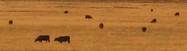
Cows
|
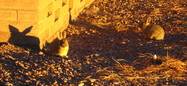
Rabbits
|

Coyotes
|

Shadows
|
We took a lot of pictures, but it's hard to capture the eerie, awesome feeling, in part because you have to take forty paces backwards (usually into a restricted area) just to fit a dish into the camera frame.

In order to get this great picture...
|

...we had to ignore these signs.
|
When the stars finally came out, we went looking for a place to spend the night. The nearest lodging was in Socorro, which still didn't have any pie. It almost didn't have any lodging, either: the first two motels were full, and the third gave us their last available room.
We wondered why the place was so packed — was a convention in town? — but we got our answer as we walked across the parking lot to our room. There were a surprising number of pickup trucks, even for this part of the country, and the men standing around seemed to be wearing an unusual amount of orange and / or plaid. Clearly it was hunting season.
Hilary looked at me and said, "I think we're the only ones here for the radio telescope."

Socorro is near the Bosque del Apache Wildlife Refuge. When birds fly south for the winter, this is one of the places they end up. We aren't really birdwatchers, but couldn't resist such a right-place, right-time opportunity.
Supposedly, the best time to visit is at dawn, when the rising sun triggers something in the birds and they all take off en masse. Waking up at daybreak is not my idea of a vacation, but at least in December it happens relatively late in the morning.
We arrived at the refuge around 6:30 AM and parked near the first marsh we saw. There were thousands of birds honking and quacking on the water, and the noise seemed to be coming from all directions. Three other birdwatching couples were already there. Mike and I were the only pair without a tripod and telephoto lens.
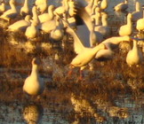
It was pretty cold, even in long underwear, a fleece, and a coat. We had to keep passing the camera back and forth to keep our shutter fingers from going numb. Mike looked at the birds and wondered aloud how they could stand the freezing water, but I reminded him that they were covered in a layer of delicious fat.
There were two kinds of birds on the marsh, tall gray ones and small white ones, and each group kept to itself. I'm pretty sure the gray ones were sandhill cranes and the white ones light geese. As the sky slowly changed color, the noise of the birds increased in volume and urgency. The cranes had been taking off a few at a time the whole time we were there, but the geese stayed put until just after the sun appeared, then they all flew away together.

It was a dramatic scene, and quite lovely against the sunrise, but I'm not enough of a morning person to ever get serious about birding as a hobby.

The path across southern New Mexico goes right through White Sands Missile Range. It's an active military testing area, and it also has historical significance as the home of the Trinity Site, where the first atomic bomb was set off. That part of the range is only open to the public twice a year, though; in fact, the only parts that are open year-round are a small museum and something called Missile Park. Still, since it was right off the only highway, we decided to drop in and have a look.
As we approached the gate, there was a big sign telling drivers to have ID ready. I was looking for my drivers license when we noticed that the cars in front of and behind us were both military — perhaps a drivers license wasn't quite sufficient. Still, we could see the museum inside the gate with a big "PARKING" sign in front, so I assumed we were headed in the right direction.

The guard was polite but intimidating, and suggested we turn around, park outside the gate, and walk to the museum. Since that looked to be a quarter mile away, we asked about the lot in front of the museum. He repeated, "I suggest you park outside the range." We followed orders and did a U-turn, which probably saved us the trouble of having our car searched.
As we once again headed toward the gate, now on foot, I decided to take the picture to the right. I mean, the sign itself is right out of WarGames, and Missile Park looked hilarious in the distance.
Within seconds another guard came rushing over — good thing I'm quick with the shutter — and told me that there were very strict photography restrictions: All pictures had to be taken facing west, toward the mountain range. Everything to the east, he told us, was, "extremely classified."

Luckily I was wearing sunglasses, so he couldn't see my eyes roll. The range is 3200 square miles — three times the size of Rhode Island — so why would they put anything remotely classified in the tiny speck that was within view of the museum? I fully intended to comply with the rule, but I knew it would ruin all our photos. You take pictures in the direction the sun is shining, so your subject is nicely illuminated. If you try taking pictures toward the sun, you end up with silhouettes, and blurry ones at that.
Hilary's going to pick up the story from here.
We stopped at the Visitor Center --- I wanted a pamphlet and Mike wanted a bathroom. But this was unlike the many visitor centers we'd encountered in national and state parks, which had been staffed with friendly rangers. This one looked more like an especially ugly bank branch, with a long desk in front and cubicles off to the side. Mike spotted the men's room and headed over, while I stood behind the other people waiting in line.
A man on his way out for a smoke, who wore neither a uniform nor a name tag, asked me what I was doing there. I said we were interested in visiting the museum and Missile Park, and wanted a map or an information pamphlet or something.

"We don't have that here," he sneered. "Isn't this the visitor center?" I asked. "No, this is for security. There's nothing for you here." "Okay," I shrugged.
"Well," he asked, "Are you going to leave?"
We'd been at White Sands for less than 10 minutes, and this was the third guy trying to boss us around. I really hate following orders that seem arbitrary and capricious but was trying to restrain myself. I did temporarily lose control of my hands as one flew to my hip and the other pointed into the air, but I held my voice steady as I informed him my husband was in the men's room and I needed to wait for him. He seemed to accept that and continued out of the building. Later, when Mike and I were safely out of earshot, I told him what had happened. He remarked, "Who would've thought that a military base would be so strict?"
Fortunately, the museum and Missile Park were cool enough to almost make up for our treatment at the hands of Defense Department grunts. Mike took pictures of all the missiles, griping all the way about the bad lighting. The museum had photos of all the scientists who worked on the early atomic bombs, and lots of their old machinery: nuclear testing equipment, safety gear, cameras, and the like.
It also had a little gift shop, and here we finally found not only maps and information pamphlets, but friendly staffers too. We asked the ladies behind the counter to repeat the photography rules, and they sighed deeply. "You can take all the pictures you want. I know they try to tell you otherwise, but it's really okay." We mentioned that a guard said we couldn't take any photos facing east, and she burst out laughing. "If that were true I'd have been locked up a long time ago!" I told them about our experience at the "visitor center," and they were as shocked as I was. "How rude!" they exclaimed.
They cheered us up a great deal, so we headed back over to Missile Park so Mike could take pictures of the other side of all the missiles.
Flying contraption
|

Launch control panel
|
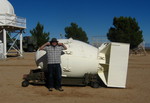
Atomic bomb casing
|
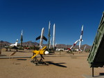
Missileaneous
|

White Sands, of course, is known for more than just munitions testing. It's also a park featuring brilliant white sand dunes made of gypsum.
It's pretty rare to find gypsum sands, because the mineral is water soluble and would normally be carried out by rivers and creeks. But because this area is a dry basin, water either evaporates or sinks into the ground.
We walked the Big Dune Trail, just a few miles from the Visitor Center. These dunes actually have a fair amount of plant life, notably the funny-looking soaptree yucca. Any plant that grows on the dunes has to get big fast, or else the wind will bury it under heaps of sand.

This tree was buried by the wind.
|

This one will survive.
|

I'm not really sure what's going on here.
|
Next we hit the Interdune Boardwalk. There's a sign at the beginning of the trail noting that the boardwalk was constructed from some kind of recycled plastic, and warning that it harbors great amounts of static electricity. It also tells us not to worry, since studies have shown that static shocks aren't harmful to our health. (Yeah, neither is getting your finger caught in a mousetrap, but you don't see me driving miles into the desert for the privilege.)
After I touched an aluminum railing and got a nasty shock that still hurt 10 minutes later, Mike recommended I touch the rails every eight steps or so to discharge the static in smaller doses. It totally worked! Now that's the information the sign should give.
Mike also had some kind of suggestion involving complimentary one-megaohm resistors. I'm sure the National Park Service will get right on that.

The staticky boardwalk
|

Soaptree yucca
|

Surrounding countryside
|
We drove the remainder of the park's loop drive, which got very sandy towards the back. It looked like the snowfields we had seen in Jacob Lake, except much of the landscape was marred by footprints. The rangers ask visitors not to leave the trails, but many people do anyway, destroying the dunes' naturally smooth contours in the process. The worst were the people who stomped their names into the dunes in giant fifteen-foot-tall letters. We'd show a photo, but we don't want to give these jerks any publicity.
Despite all this, the park was beautiful and we wished we'd had more time to enjoy it. Here are a few more pictures, and as usual you can see the others on Flickr.

|

|

|

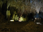
Our last stop in New Mexico was Carlsbad Caverns. We had spent the previous night in the town of Carlsbad, so we thought we could sleep in and get brunch before going to the caverns. It turns out that the caverns are 40 minutes outside of town, and so it was 12:45 when we arrived at the gate.
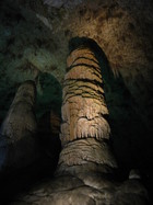
So here's how Carlsbad Caverns works: the entrance is a hole in a cliff with a long path looping 750 feet downwards until it reaches an underground junction known as the Big Room. The Big Room has all the modern amenities: bathrooms, snacks, and even an elevator back to the surface. It's also the meeting point for a guided tour through the best parts of the cave, with mineral formations so elaborate and delicate that they won't let you in outside the tour.

The salesranger upstairs told us that we had a choice to make: The last tour would leave at 2:00 PM, which was an hour and fifteen minutes away. However, the walk down to the Big Room took 90 minutes. We could skip the guided tour, or we could skip the natural descent and just ride the elevator down.
I asked if it would be possible to ride the elevator down, see the tour, and then see the natural entrance on the way back up. "No," he said quite gravely, "Nobody walks up the path." I guess it was some combination of too strenuous and too disruptive of visitor traffic.

We decided that since we were New Yorkers (and had to pee) we could easily complete a 90-minute walk in 75 minutes. We hurried over to the entrance and began our descent.
In our haste we had forgotten to bring spare camera batteries, which was starting to look like a huge mistake. The battery warning light was already on, the natural entrance trail looked amazing, and using a flash in the dark tunnels would drain too much of our remaining power.
Fortunately by now we had gotten pretty good at taking pictures in the dark, and the lessons we had learned outside at night applied to the caverns as well: pictures taken while holding the camera looked crummy and blurry, and pictures taken with the camera resting on a surface looked crisp and spectacular.

|
|
|

|
We ended up arriving in the Big Room with half an hour to spare. Upon arrival, we saw the most beautiful sight of all: fresh batteries for sale! At this moment, I was very glad we had selected a camera that ran on ordinary AA batteries, since more exotic varieties are seldom found 750 feet underground. They didn't have rechargables, but I suppose beggars can't be choosers.
The guided tour was everything it was cracked up to be, with stalactites and stalagmites and stalazbrites (okay, I made that last one up) all over the place. The ranger's commentary was pretty informative, too. Some things we learned from her:


It turned out we didn't need our flash after all; the photos in which we used it were uniformly terrible. The formation in the foreground would be overexposed and everything else, pitch black.
The guided tour lasted two hours, right up to closing time. A few friendly rangers let us run up a trail for a few final pictures, then we turned around and took perhaps the last elevator of the day back to our car. We left New Mexico through its eastern border and headed across Texas to Oklahoma City.
Previous spot: Arizona -*- First time here? -*- Next spot: Oklahoma
If you'd like to be notified when we post a new spot, you
can join our announcement list. We won't use your address for
anything else or share it with anyone, and
the link to
unsubscribe will be at the end of every message.
